Popular pages
- Check details and progress of applications.
- Information on the Brentwood Borough Council elections due to take place on Thursday 2 May 2024.
- Get help and advice from local and national organisations.
Popular services
Community organisations, safety and services for younger and older people.
Payments, discounts, support, housing benefit, local housing allowance and UC.
Finding a home, strategies, rights and responsibilities, disabled facilities grants.
Advice, apply, policies, local plan, land charges, conservation and enforcement.
How to vote, polling stations, postal and proxy votes and election results.
Services for households and businesses, what to recycle and collection days.
Latest news & events
 News
NewsWith the voter registration deadline approaching for local elections being held on Thursday 2 May, anyone wanting to vote must make sure they are election ready
 News
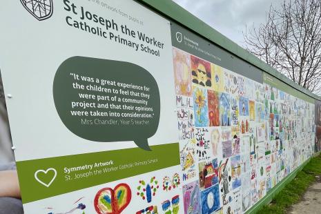
NewsArtwork created by Willowbrook and St Joseph the Worker Primary School pupils around sustainability and homes of the future is the main feature of newly installed hoardings surrounding Brentwood Borough Council’s first zero carbon development at Brookfield Close in Hutton.
 News
NewsThis issue, which will be delivered to residents across the borough, features council and community news and helpful information ahead of the May elections.

Brentwood Connected
Brentwood Connected is a unique Business Improvement District (BID) supporting our borough’s three high streets. Brentwood Connected is funded by town centre businesses to improve the experience of residents, visitors, employees and businesses in Brentwood, Shenfield and Ingatestone.

Cost of living
Get help and advice about the cost of living from Brentwood based and national organisations.
My Property
You can now use our maps to look up things in your area such as waste collections, ward information, polling stations and more.